
Following the success of EFT-4 we went back to the drawing board to do a minor redesign of the “DogeShip-Class” spacecraft. We decided to re-do a few things based on lessons that we had learned in the first four flights of the ship. Improvements included a more robust mounting system, onboard labeling to comply with FAA regulations, software improvements to enhance the telemetry system, and a secondary source of telemetry information.
Flight Plan:
The launch weekend (13 March 2016) was set following an initial look at the weather and running some preflights. In order to ensure that the launch and travel distance would not conflict with the Washington DC Special Flight Rules Area, the original preflight method was scrapped and a new, more robust method was developed using a Monte Carlo simulation. (We’ll talk more about Monte Carlo sims in a subsequent post.) This analysis was used to show beyond a reasonable doubt that we could not in any way intersect the restricted airspace around Washington, DC.

Monte Carlo Analysis showing possible impact locations. Color indicates different launch times.
Launch Day:
One of the critical process differences between this launch and prior launches is that a final launch location was chosen the night before. We picked a school with a large parking lot in Moorefield, WV with the landing blob centered on farm areas and clear of forests. On prior missions, we had always selected a landing location and, while driving, worked our simulator in reverse to find the best launch area. With the new Monte Carlo analysis we were targeting a landing area - and as long as the center of the Monte Carlo spots was in a desirable area, then a launch location could be finalized a day or two before launch. This significantly simplified our launch day and will be standard for future launches.
Another improvement to the process was that almost all rigging and balloon prep work was performed the night before, meaning we are approaching an ‘unpack and launch’ style for the weather balloon. This launch was a proof of concept of this style, and was prepped and made ready by two people in 40 minutes, a pretty remarkable improvement from previous flights. (This was also super helpful because it was raining!)
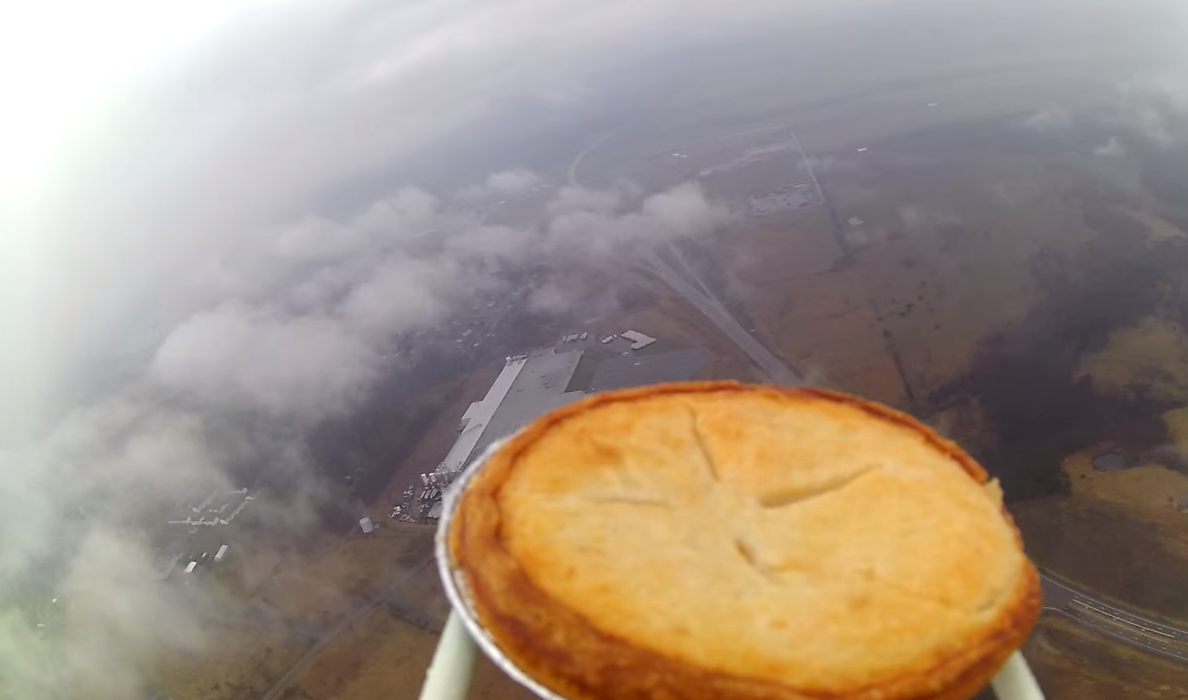
One of the key differences between this flight and prior flights is that this was a photography mission: We had an upcoming flight that required video of an object attached to the outside of the payload. In order to be confident in that mission being successful, we prototyped the video rig for testing on this flight. Being a launch barely before International Pi Day, we attached an apple pie to the payload boom to be the first (that we know of) to send an apple pie up on a weather balloon!

Yep - that's an apple pie!
Launch Log:
Time of Launch: 11:40 AM EST Launch Coordinates: 39.072, -78.933 (Eastern Dr, Moorefield, WV 26836)
Time of Landing (in-hand): ~12:46PM EST Landing Coordinates: 39.33, -78.31
Time of Recovery (in-hand): ~4:46PM EST
Let’s start with the good news: the flight went off almost perfectly; the SPOT satellite tracker allowed us to get in-flight updates and allowed us to estimate a final landing point within a half-mile based on the trajectory it was taking. Now, the less good news: the balloon burst about 10,000 feet below where we expected, exposing an error in our balloon burst altitude math. This was a good failure as it will make our future launch predictions much more accurate. The descent was a little faster than planned, possibly meaning that the parachute rigging had become fouled.

In-Flight Recording of EFT-5's path through West Virginia.
We collected our first ever video of the descent of the Dogeship under parachute and discovered that our rigging method produced rather violent oscillations in pitch and roll, clearly seen in the video. This will be fixed on follow-up flights.
The targeted landing area was in the center of multiple miles of farm fields - the actual landing occurred 10 miles short in a forest (again... EFT2 is still in a tree). The long line between the parachute and payload meant that even though the parachute was caught 80 feet up, the payload was only 35 feet off the ground, within our ability to retrieve it.

The pie was ejected from the Dogeship on landing/impact!
How we actually got the Dogeship down is a LONG story, but suffice it to say it involved a trip to the hardware store; 70 feet of PVC pipe (of which we used 40); a crap ton of duct tape; and several sharp objects. Basically, we (my wife and I) created a giant pole with a utility knife, sawzall blade, scissor, and hook attached to the end. After three hours in the rain maneuvering “pokey-slicey-claw-stick”, the payload was finally brought down! (Our thanks to the owner of the property for putting up with us!)

Suspending this 35 feet above our heads was probably not smart, but it got the job done! Also, my wife is a rockstar for supporting and assisting for four hours in the pouring rain
Conclusions:
All mission objectives were accomplished, and we learned a lot about how to improve our launch process with this flight. The video taken during flight became over-saturated with light once it got above the clouds, which resulted in the decision to no longer fly the RioRand Action Camera and instead to switch entirely to GoPro cameras. It is likely that if it had not been so cloudy the RioRand would have performed well, but the GoPro should guarantee high quality video regardless of conditions.
This flight proved that we were ready for an upcoming flight opportunity that had presented itself... more on that soon!
Flight Summary
| Date | 13 March 2016 |
|---|---|
| Equipment | DS Rev 5 |
| Launch | Moorefield, WV |
| Landing | Cross Junction, VA |
| Time of Flight | 66 minutes |
| Distance Travelled | 38 miles |
| Burst Altitude | ~55,000 ft |